
On Tuesday afternoon, September 1, Tropical Storm Edouard came ashore near Johnson Bayou in Cameron Parish with maximum sustained winds of 60 mph. It had been a named storm for barely a day. By the time it weakened inland, it had downed trees and power lines and left more than 150,000 customers without electricity across southwest Louisiana and the upper Texas coast. And NOAA is still forecasting a below-normal season. Both of those things are true at once, and the gap between them is where a lot of Louisiana homeowners get caught.
What "Below-Normal" Actually Measures
NOAA's August update kept the 2026 season in the below-normal category. Forecasters project 7 to 13 named storms for the full June-through-November season, of which 2 to 6 could become hurricanes, including 0 to 2 major hurricanes. They put the odds of a below-normal season at 75 percent, with a 20 percent chance of near-normal and just 5 percent above-normal, driven largely by El Niño conditions that emerged in the equatorial Pacific in June.
That forecast is a basin-wide count. It predicts how many storms will form across the entire Atlantic, Caribbean, and Gulf combined.
It says nothing about where those storms go.
A season can produce half the usual number of storms and still put all of them on the same stretch of coastline. That is roughly what has happened here.
Three Named Storms, Three Louisiana Landfalls
Arthur became the season's first named storm on June 17, forming in the warm Gulf off the Texas coast and making landfall on the upper Texas coast that afternoon. Its landfall was in Texas, but according to NOAA, Arthur brought record rainfall to portions of Louisiana and spawned tornadoes along the Gulf Coast. Its winds never exceeded 45 mph.
Bertha formed on July 19 south of the Florida panhandle and made landfall in St. Bernard Parish on July 22 with 45 mph sustained winds. It then drifted back over open water and came ashore a second time near the Texas–Louisiana line the following day. Two Louisiana landfalls from a single disorganized storm. A peak gust of 63 mph was recorded in Venice.
Edouard developed overnight on August 31 and hit Cameron Parish on September 1 with 60 mph sustained winds. Gusts reached 71 mph near the Texas–Louisiana border.
Three named storms affecting this state. Three landfalls on Louisiana soil. Zero hurricanes. A quiet season by the basin-wide numbers, and a busy one if you live here.
The Calendar Is the Part People Miss
Here is the uncomfortable timing. The climatological peak of the Atlantic hurricane season is September 10, and the most active window runs from roughly mid-August through mid-October. Historically, about 60 percent of an average season's activity still remains after September 10.
Everything above happened before the most active stretch of the year. We are entering the peak, not leaving it.
Wind Is Not the Only Thing That Damages a Roof
There is a common assumption that a storm has to reach hurricane strength before it is worth worrying about. Edouard topped out at 60 mph — well below the 74 mph hurricane threshold — and still took down enough infrastructure to leave six figures of households in the dark.
Roofs come apart at lower wind speeds than most people expect, and they usually come apart in ways you cannot see from the driveway.
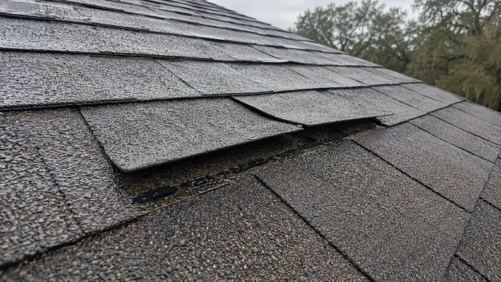
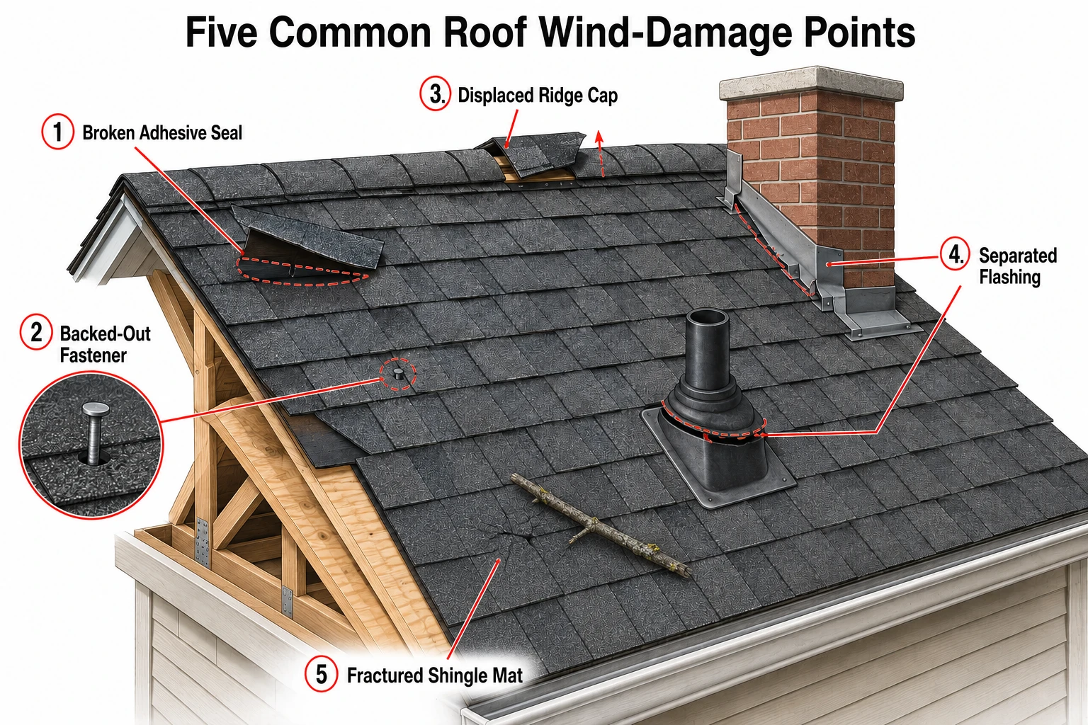
Lifted shingle tabs. Sustained wind in the 50 to 60 mph range can break the adhesive seal along a shingle course without moving the shingle out of place. It looks fine from the ground. The next rain gets underneath it.
Backed-out fasteners. Repeated flexing works nails loose. The shingle stays put; the nail head starts to protrude and eventually punches through from underneath.
Ridge cap and hip damage. These take the highest wind loading on the roof and are the first place we check after any storm.
Flashing separation. Chimneys, sidewalls, plumbing boots. Wind-driven rain does not need a hole. It needs a gap that a vertical rain would never have found.
Debris impact. A pine limb landing on an asphalt shingle roof can fracture the mat without penetrating the surface. That fracture becomes a leak six months later.
North Louisiana Is Not Out of Range
If you are in Monroe, Shreveport, or anywhere along the I-20 corridor, the natural assumption is that tropical systems are a coastal problem. Arthur is the counterexample: its worst effect in Louisiana was rainfall, not wind, and it reached well inland.
Tropical systems that lose their wind speed do not lose their moisture. They slow down, stall out, and dump. National Hurricane Center analysis found that rainfall flooding accounted for about 57 percent of direct U.S. deaths from tropical cyclones between 2013 and 2022 — more than storm surge and wind combined.
For a roof, an inland tropical rainstorm is arguably a harder test than a coastal wind event. Hours of steady, heavy rain will find every marginal flashing detail, every clogged valley, and every gutter that cannot keep up. A roof that sheds an ordinary Louisiana thunderstorm without complaint can fail under eight hours of tropical rain.
How to Prepare Your Roof for Peak Hurricane Season
Peak season is starting. This is the window. Five things worth doing in the next two weeks:
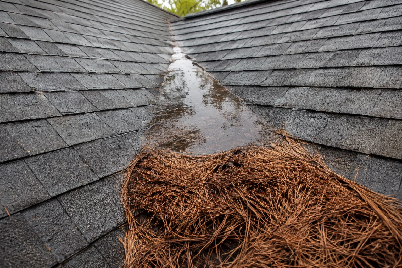
- Clear the valleys and gutters. Pine straw in a valley is a dam. It holds water against the shingle surface long enough to work underneath it. This is the single highest-value thing most Louisiana homeowners can do themselves.
- Trim back overhanging limbs. Anything within about ten feet of the roof plane is a candidate to come down in a 50 mph gust.
- Photograph the roof now, while it is intact. Dated photos of your roof in its current condition are worth having later. Shoot from the ground on all four elevations.
- Walk the perimeter after every storm. Look for granules collecting at downspout outlets, shingle pieces in the yard, and any course that looks wavy or raised compared to the ones around it.
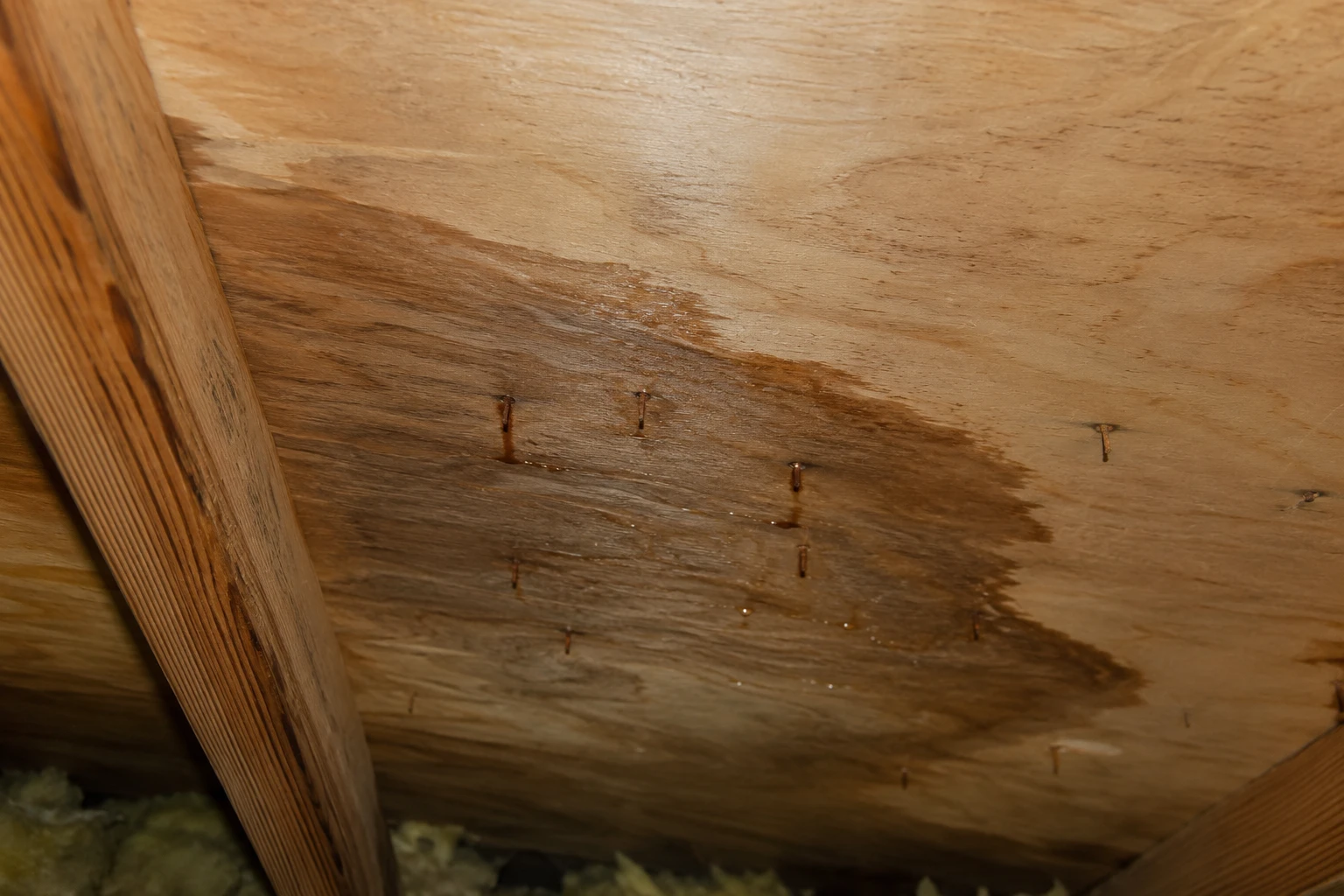
- Check the attic during the next hard rain. Bring a flashlight and look at the underside of the decking, especially around the chimney, vents, and along the ridge. Wet decking, dark staining, or rusted nail tips show you where water is getting in before a ceiling stain ever appears.
One thing not to do: stay off the roof yourself. Wet or storm-damaged roofing is genuinely dangerous, and walking on compromised shingles causes damage that was not there before.
When to Bring in a Professional
Call for a proper inspection if you see interior ceiling or wall staining, daylight visible in the attic, missing or displaced shingles, damaged or separated flashing, a significant amount of granule loss in the gutters, or any impact from a limb or debris.
Also call if your roof is over 15 years old and has been through this season. Age plus three tropical systems is a combination worth having looked at before October, not after.
If a storm does produce real damage, documentation matters as much as the repair. We photograph and write up what we find in a form an adjuster can work with, and we will meet your adjuster on site at no charge. We do not take an Assignment of Benefits and we do not inflate a scope to pad a claim — the report reflects what is actually on the roof.
Frequently Asked Questions
Can a tropical storm damage my roof if it never becomes a hurricane?
Yes. Sustained winds in the 50 to 60 mph range can break the adhesive seals between shingle courses and work fasteners loose without displacing a single shingle. Every 2026 storm to reach Louisiana stayed below hurricane strength, and Edouard alone still knocked out power to more than 150,000 customers.
Does a below-normal hurricane season forecast mean my roof is safe?
No. Seasonal outlooks predict how many storms will form across the whole Atlantic basin. They do not predict where storms make landfall. The 2026 season is running below normal by basin-wide count and has still produced three Louisiana landfalls.
When is the peak of hurricane season?
September 10 is the climatological peak of the Atlantic season, with the most active window running from roughly mid-August through mid-October. Roughly 60 percent of an average season's activity occurs after September 10, so early-season quiet says little about what follows.
How do I know if my roof was damaged after a storm?
From the ground, look for granules in gutters and at downspout outlets, shingle fragments in the yard, and any shingle course that looks raised or wavy. Inside, check the attic during the next hard rain for wet decking, staining, or rusted nail tips. Much wind damage is not visible from the driveway, which is why a hands-on inspection is worth having.
Should I get my roof inspected before or after a storm?
Both, ideally. A pre-season inspection catches marginal flashing and worn seals while there is still time to correct them. A post-storm inspection documents what changed. Dated before-and-after evidence is the strongest position to be in if you later need to file an insurance claim.
Is inland Louisiana at risk from tropical systems?
Yes, primarily from rainfall rather than wind. Tropical systems that weaken inland retain their moisture, slow down, and produce prolonged heavy rain. Arthur's largest effect in Louisiana this season was record rainfall well away from the coast.
Get Your Roof Looked At Before October
The forecast for the rest of this season may well hold at below-normal. It has already proven a poor predictor of what shows up over Louisiana. Brown's Roofing has permanent offices and local crews in Monroe, Shreveport, Baton Rouge, and Lafayette, and we inspect roofs across all four markets. An inspection tells you what condition your roof is actually in and what, if anything, needs attention — whether that is a repair, a full roof replacement, or nothing at all. Call (318) 329-6579 for a free inspection with same-day response. No obligation attached to it.